2 Old Hippies


Leave a comment

BTV to Park Frontenac

The trip starts in very familiar territory -Franklin  County and the Eastern Townships  of Quebec. We stop in Sutton at a wonderful little cheese and charcuterie shop for our lunch fare — Tomme from Kamarouska, and a Brebis made by the good Brothers of the abbey on the lake. A dried sausage from St Jean Port Jolie, and a baguette.

On the way to Parc Frontenac we run into thunderstorms, but this trip we don’t have to set up a tent in the rain, a big improvement over our honeymoon trip. We learn on arrival that there’s no electricity in the park, but that means better dark sky viewing once the clouds clear out. This part of Quebec is an internationally designated “Dark Sky Reserve,” where the municipalities have instituted controls over lighting, to keep the night sky intensely star-filled. We’ll have to wait for the moon to wane to get a good look….on the way back in a week.

Rain stops long enough to make dinner outdoors. Then loons on Lac St Francis, reading by lanternlight, and a comfy sleep in a dry bed, scattering of rain on the roof.

Advertisement


1 Comment

Fundy National Park – Where Even Superlatives Fail Me

Continuing north, and at the end of a road that goes nowhere else, is Fundy National Park of Canada, where the Caledonia Highlands Plateau (the uppermost reaches of the Appalachian Mountains) meets the Bay of Fundy.

20140914_104149There are sloping, meadow-like highlands

20140913_135134and rainforest jungles (accessible by cantilevered board walkways and stairs – it strikes me that this spot is one of the most beautiful I’ve ever visited, as deep and rich and wet as anything I’ve seen in Washington state or British Columbia).

fundyparkpano1

fundyparkbeautyplace1And of course, all-hell-broke-loose (well, it took 1 billion years, but still … ) geology everywhere.

Herewith, illustrations with text provided by Parks Canada’s Fundy Park guide.

“Around Alma and Herring Cove the story is one of rivers and jungles. The grey and beige rocks forming the impressive cliffs of Owls Head are made of sandstone.20140914_120744This rock used to be sand and mud which a vast and ancient river lay down during the Carboniferous era (about 325 million years ago). Along this river there was a lush, tropical jungle.  The rock has a fine sandy look to it and contains many black plant fossils and thin seams of coal.

The story is considerably older at Point Wolfe where volcanoes and the movement of the continents have formed the oldest rocks in the park. Walk down the steps to Point Wolfe beach

20140914_120620and as soon as you reach the beach you will notice some grey, green rocks forming a low cliff along the right side of this inlet. The rock has been smoothed by the tides but the story can still be deciphered.20140914_122757_LLSVolcanoes erupting ash and lava created off-shore islands during the Pre-Cambrian era (one billion years ago). Afterwards, during a collision between the continents of Europe and North America, these volcanic islands were bulldozed into the mainland. Look for the white quartz veins, swirling folds and criss-crossing fractures in the rock, which tell of this transformation. Rocks, which have undergone changes due to the heat and pressure of continental collisions, are called metamorphic rocks.

Point Wolfe is a geologist’s paradise. Opposite the grey rocks, you will notice rusty, maroon coloured cliffs towering above you. (JK note: yes, visit at low tide…..)20140914_122252The rusty red cliffs tell a tale of crumbling mountains. These mountains were created by the ancient Pre-Cambrian volcanoes and by the collision of Europe and North America. At one time they rivaled the Rockies in massive splendour. But they were worn down, or eroded, by the passage of time. Water and gravity piled all of the debris at their feet. These boulders and pebbles were later cemented together to form a new rock which we call the Hopewell conglomerate.

Think about that for a moment: “The collision of Europe and North America…”  “rivaled the Rockies in massive splendour…” , and not only that, but the highest tides in the world. (Yep, in the photo below, that’s a kelp bed on the right …)20140914_121430Words do fail me, and that’s saying a lot.


4 Comments

Behold the Road Cut

2oldhippies love fresh bread, the smell of fresh laundry from the clothes line, and as you might guess if you’ve been reading the blog, fresh road cuts.

20140912_164436

We are old enough to remember when the interstate highway system was built. One of us cannot remember the new roadcuts created then back in Tennesee, but in Montana where I grew up, the road had to blow through (literally, with a lot of dynamite) a canyon of the Missouri River between Great Falls and Helena. (near the stretch of the Missouri River that Lewis and Clark named “Gates of the Mountains.”) Those fresh road cuts were so awesome, so beautiful, and so revealing that my brother, who had just selected geophysics as his university major and was quickly turning into a rockhead, made us all take a field trip on the new highway just to pull over and look at the fresh road cuts. I’ve loved them ever since, and my reaction is pretty much the one with the snapped head and the word “Squirrel!” only I say “Roadcut!”

Here in Vermont, the Interstate construction did much the same service, opening up the inside of the earth for closer inspection, and Vermont is very interesting, geologically speaking. Periodically, our beloved rockheads at the Agency of Transportation decide to widen the cuts, clean up after rock slides and such, and we are treated to fresh roadcuts (thus increasing my driving time between Burlington to Montpelier, rather the decreasing it, I might add.)

Our original 2014 adventure travel plan — US 2 West, then down the Rockies through Wyoming to Boulder/Denver, included following the Interstate route through Wyoming that got another roadcut fiend, John McPhee, all excited, and which he wrote about in detail in Rising from the Plains, a great read about the geologic history of the Northern Rockies. We were all set to marvel at those road cuts. It was the geologic wonders of New Brunswick and the Bay of Fundy that gave us our alternative destination once our plans had to change, but we didn’t know that the relatively new Fundy Trail Parkway was waiting for us with dozens of fresh “Roadcuts!” Wow. As everywhere along this coastline, bending, folding, piling on, intrusion, uplifts, hundreds of millions of years of “all hell breaking loose” on display. And in case you can’t get here soon enough to see them in their fresh state, before mosses, lichens, mineral leaching and other aging processes dull them, we are pleased to offer you our views.

Behold the Road Cut!

20140912_163511

20140912_163634

20140912_164104

20140912_164306

20140912_164558


6 Comments

Rules for Rummagers

When 2oldhippies were growing up, the term our parents used for searching for, digging around for, otherwise searching high and low for something, was called”rummaging.” Rummaging is sometimes unavoidable, sometimes pointless, sometimes a total waste of time.

We learned on our honeymoon camping trip to the Gaspe Peninsula nearly 30 years ago that to make rummaging as productive as possible, certain rules had to be set down and agreed to by all parties. On such an extended camping trip, absent said rules, we’d be spending a lot of time rummaging and not enough time enjoying it all. We bought a small blank booklet and developed “Rules for Rummagers.” (Actually, because we were in Quebec, we included the alternative title “Les Regles des Rummageurs.”)

We’ve added to the Rules over time as we’ve continued to live out of small places for extended periods: camping out of a car or canoe, navigating a French river in a small power boat, and now in the Westy. And frankly, the Rules apply pretty well when any two people live under the same roof in a small house and need to find/use the same household equipment.The rules do seem obvious, common-sensical even. The imporance is the agreement – this can reduce annoyance and aggravation, as well as the use of language that would make a sailor blush (as in: Where the @#%^   did you put the   *()@%(#&ing  !%*#*^ ??????

(Of course, as 2oldhippies get older, we do forget the rules, just as we often forget what we were looking for in the first place. The Rules cannot help you with that problem … Be patient with each other, is our only advice there.)

So, herewith, a few Rules for Rummagers:

1. Once there is agreement on where something is going to be stored, don’t move it. If you use something, put it back where you found it.

2. Rule #1 applies even if you later believe you have “found” a better place to put it.

3. When something new is acquired along the way that will be used frequently, decide and agree right away where it will be stored, and following #1.

4. Looking for something just to confirm that it’s still there is not legitimate rummaging; it’s either the aging process, or a touch of OCD or paranoia (take your pick). So cut it out; you are making ME nervous.

5. Do not rummage in other people’s stuff, no matter how interesting it looks. A corollary to this rule is keep your eyes on the road when you are behind a full pickup truck, because you’ll never get to rummage in that stuff anyway, even if you follow them home.

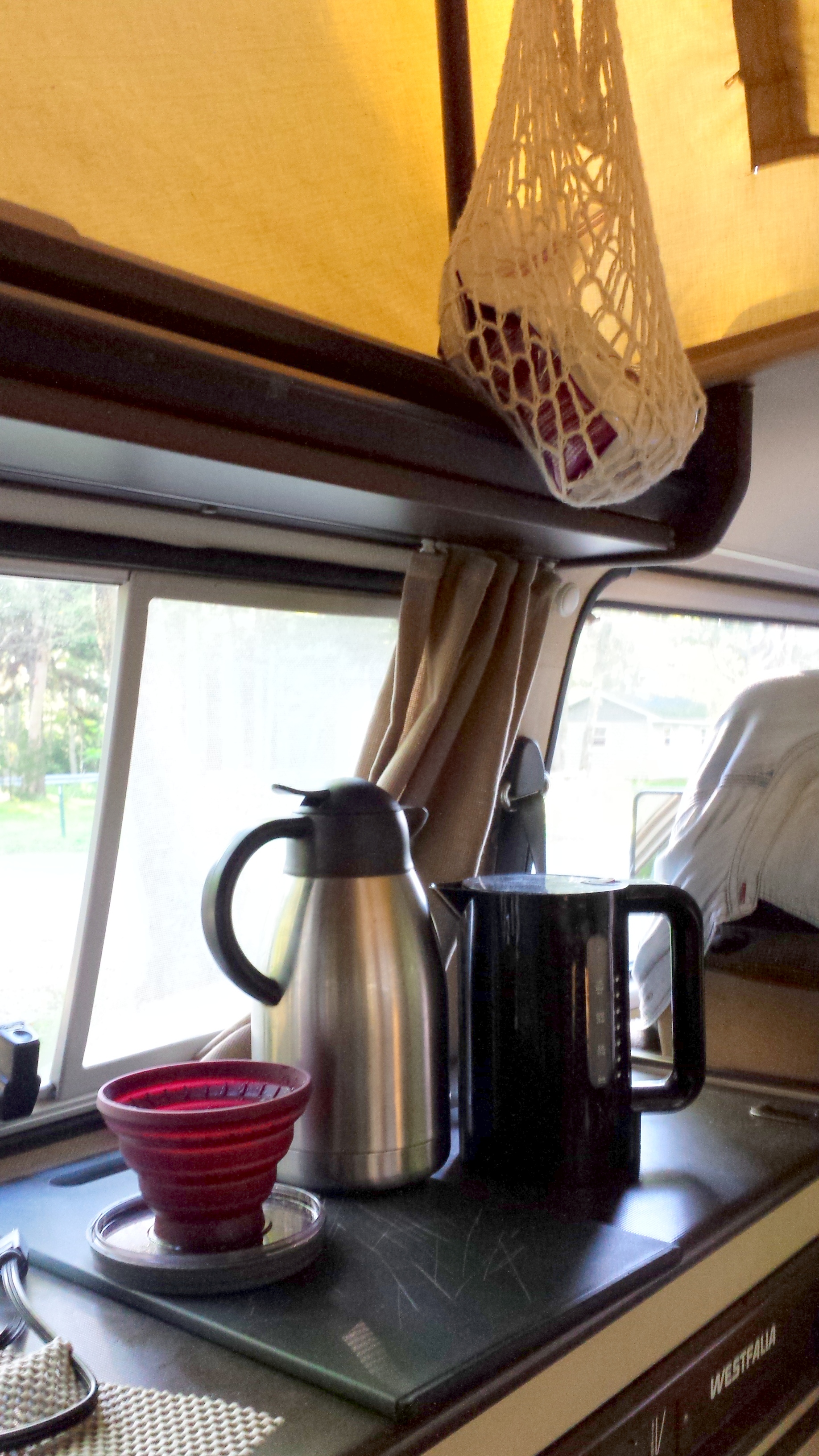
2oldhippies came up with some hacks to help enforce the rules and minimize some kinds of rummaging — such as, crocheting a lot of little bags to gather together stuff that belongs together, to keep it together and make retrieving it easier. One of our little bags contains everything necessary to make the coffee in the morning: filters, a miraculous collapsible silicon filter holder (the red thing to the left of the carafe in picture below), ground coffee, sugar, spoon, and coffee cups. No rummaging required early in the morning – everything needed is already in one place.

20140915_083247Another kit is my “going to the shower house” bag: small bottles of shampoo, body wash, face wash, razor and a poof in a net bag that can hang in the campground’s shower and then hang back in the Westy to dry out.

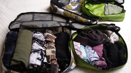
While we technically have room for suitcases or backpacks, getting in and out of them is a drag, and after a couple of days, there’s a lot of rummaging involved within those containers. I pack instead in small zipper packs (sometimes called packing cubes), and then stack them in the closet – one for underwear and socks, one for shirts, one for pants. Roll items up to make them easy to pick out. A separate one serves as a “dop kit” for toiletries. (Limiting yourself to a small amount of space for your stuff is a very good way to limit rummaging anyway….)

20140922_173608

What are your Rules?


8 Comments

The Fundy Coast: St. Martins

A short drive north of Saint John is St. Martins. Look at a map of the NB coast and you’d think only Anglicans and Roman Catholics settled this area for all the saints memorialized here. And while I’m on the saint thing:  inquiring minds want to know why Saint John is always presented with “Saint” spelled out, but St. Martins, St. George and St. Stephen use the abbreviation. And while we are at it, why is St. Martins plural or did they forget the apostrophe? I’m sure there are stories behind all this; there usually are. I just forgot to ask.

20140912_120610St Martins is formerly a sleepy fishing village and now a sleepy (in the off season) village of inns , B&Bs, and campgrounds, along with lovely beaches, spectacular sea caves, and the crazy tide lands. It sits on a small bay of the great Bay, between some striking headlands, and is the gateway to the Fundy Trail, a relatively new provincially developed parkway, bike and hiking route that eventually will connect Saint Martins to Fundy National Park. We try to bike the parkway bikepaths, but they are for youngerhippies or oldhippies with better knees. Steep up and downs hugging the coastline; great for those we think of as “mountain bikers”, so the 2oldhippies Westy ourselves around and hike instead. Everywhere extraordinary coastline views and,oh yeah, more rock love – a lot more.

The coastal views are similar to Mt. Desert/Acadia, except that there are a lot fewer people, huge tide flats twice a day, few sandy beaches, and it's hard to find a motel or gift shop.

The coastal views are similar to Mt. Desert/Acadia, except that there are a lot fewer people, huge tide flats twice a day, few sandy beaches, and it’s hard to find a motel or gift shop anywhere.

When the tide goes out, it goes to where the color of this water changes. Yeah, that far out.

When the tide goes out, it goes out to where the color of this water changes. Yeah, that far out.


The Fundy Trail astonished us at the scale and scope of this public investment in a roadway, bike and hiking path network that is not a through route to anywhere, and whose only purpose is recreation and sightseeing. At one of the great view-sheds, this tiered group of picnic sites, which we made use of for a rose sundowner ...

The Fundy Trail astonished us at the scale and scope of this public investment in a roadway, bike and hiking path network that is not a through route to anywhere, and whose only purpose is recreation and sightseeing. At one of the great view-sheds, this tiered group of picnic sites, for example …


This is a view from the end of Phase I to the beginnings of Phase II of the Fundy Trail Parkway. Eventually, it will extend from St Martin's all the way to Fundy National Park. The land in between is currently wilderness. Yeah, that's different from Acadia, too...

This is a view from the end of Phase I to the clearing and construction of Phase II of the Fundy Trail Parkway. Eventually, it will extend from St Martin’s all the way to Fundy National Park. The land in between is currently wilderness. Yeah, that’s different from Acadia, too…

St. Martins is a Stonehammer Geoparc site.

Just left of the sea caves that all tourists can see and enjoy is an important "contact" of two different geologic formations -- the light colored Quaco, and the red Honeycomb Point formation. The shrubs and foliage growing along the diagonal contact disguise it during warm months...

Just left of the sea caves that all tourists can see and enjoy is an important “contact” of two different geologic formations — the light colored Quaco, and the red Honeycomb Point formation. The shrubs and foliage growing along the diagonal contact disguise it during warm months…

Sea caves at St. Martin's, low tide.

Sea caves and formation contact at St. Martin’s, low tide.

"The Sphinx"

“The Sphinx” at the St Martin sea caves formation


Nope, not a painting by someone from the St. Martin artist colony - a freshwater stream flowing from a spring near the sea cave passes beside the seaweed deposited when the tide covers this area. The red-orange above is the Honeycomb Point Formation sandstone. A really lovely sunset scene.

Nope, not a painting by someone from the St. Martins artist colony – just a mossy freshwater stream flowing from a spring near the sea cave passing beside the brown-green seaweed deposited when the tide covers this area. The red-orange above is the Honeycomb Point Formation sandstone. A really lovely sunset scene, but only visible at low tide, when the stream is not inundated by the sea.

Sunset view from our campsite.

Sunset view from our campsite. Still low tide.

Sunrise the next morning, with the tide in.

Sunrise the next morning.

We are inspired to keep moving farther up the Bay. Next stop Fundy National Park.


5 Comments

The US 2 East Adventure, Part II: Palmyra, Maine to the eastern end of US 2, at the border with New Brunswick

Maine’s rivers are big, and we followed two along US 2 – the Androscoggin and the Penobscot. They look placid now, in September, though clearly running deep and moving a lot of water. The fog had settled in over night, and we drove through it nearly to Bangor. When we broke through it felt like a perfect late summer day — green fields, blue sky. Leaves haven’t started to turn yet. We are entering logging country, and US 2 being only two-laned here, the Westy shudders when the big logging trucks tear by us.

At Bangor US 2 takes a sharp left turn to the north, and follows the Penobscot.We stop for a late breakfast along the river, off a very nice stretch of new paving, a condition we have been calling “New 2,” as there are several paving projects along our route.

1-20140910_092028

We had to stop again on this height of land, a cemetery with a great view of Mt. Katahdin in Baxter State Park directly west of us.

1-20140910_104136

We are surprised to learn Rt 2 in Maine is home to an Amish country.

1-20140910_105314

After giving up a couple more classic views of the Penobscot,

1-20140910_112048

US 2 turns hard to the east, and Houton, Maine, a bustling border town, and then suddenly — to suddenly to even take a photo of the sign, the End of US2. And the border with Canada.

20140910_120314

New Brunwick from Houton to Frederickton (the provincial capital) is scrubby land and scraggly trees. They aren’t great and grand enough to harvest, and nothing else seems to be happening here. No farms, fields, pastures, meadows. It is empty of people, agriculture, towns. We learn later, at the fine New Brunswick Museum in Saint John, that as much as 2/3 of the province isn’t arable. It looks like what you’d imagine a place looks like a 150 years after it has been clear cut, when the soil isn’t good enough for the forest to re-establish itself. We also learn later this is a result of geological hell breaking loose here, consecutively fracturing, folding, washing away, covering with ice, and then scraping away the land.

But then at Frederickton we join rivers again. And follow the NB River Route along the Saint John River. With each new tributary, the river seems to grow exponentially, until eventually it is like driving along a lake.

20140910_161543 20140910_162802

And with a river, better soil, and with better soil, people: farms, orchards, busy towns. And roads, and cars and again, trucks.

Finally, late in the afternoon, we crest one last hills and see the city of Saint John, and the river flowing into the Bay of Fundy.

Our campsite is well run campground on the edge of massive city park. Thank you, City of Saint John. We pop the top, set up the bed, and jump on our bikes to go into the city for dinner. Little do we know the reason there are no bike lanes and no other folks on bikes is that the city is built on several hills. It’s not a single slope to the Bay, as Burlington slopes to Lake Champlain, or flat like Boston. Saint John is more San Francisco-like, with hills leading to more hills. We exhaust ourselves wandering around downtown Saint John and steepest climb, of course, is back to the campground. It’s a lovely little city, though, with beautiful neighborhoods and stunning stone buildings all through the downtown. (More on this to come).


7 Comments

The US 2 East Adventure Part 1: BTV to Palmyra, Maine

US 2 East, Burlington, Vermont to Palmyra Maine.

Before peak foliage, there is peak green.

20140909_123810

US 2 east took us from Burlington along the Winooski River through Montpelier, Plainfield and Marshfield, where we parted ways with the river, and continued east to Danville, St Johnsbury and across the Connecticut River. Stopping for the first view of the Presidential Range outside of Danville took almost as long as driving across the narrow neck of New Hampshire.

1-20140909_124528

“This car did not climb Mt Washington,” but I did take a selfie as we flew past. (I will spare you my photo of Santa’s Village.)

1-20140909_142128

Our first night was in Palmyra, Maine. My paternal great-grandfather, George Millett, was born here in the mid-19th century, and there are still some Milletts living here, and plenty more resting here in the bosom of Abraham. George’s daughter Maude, my grandmother, was born in Wisconsin as George followed the timber harvesting business across the continent. They ended up in Libby Montana where Maude and Frederick Keller brought forth my father, Millett Frederick Keller. Who grew up on US 2, which runs through Libby. Really, it does.

So, back to Palmyra. I visited the newer  Millett place, which sits right on US 2. I took this photo at 6AM as we left town, and no one was up yet. We’ll visit on the flip side of the trip. I visited Palmyra back in the early 1980s, and the building on the left was the General Store, Millett’s by name, and the proprietor, one George Millett, took me to visit the cemetery. I figured him to be a second or third cousin, and e didn’t know he was named after his great (perhaps two greats?) uncle. The store is now closed, and last week I saw his obit in an online local newspaper as I was planning this trip.

1-20140910_065912

There are more Milletts resting a couple miles off US 2. Herewith, for the genealogists in my family, are some photos.

1-20140910_0711551-20140910_072243

Thomas, on the left, is my great-grandfather George’s father, who moved to Palmyra from Leeds, MA. His father Thomas was the reason Maude (and me and my sisters and nieces and great-nieces for that matter) are eligible for the Daughters of the American Revolution. (I toyed in the 1990s with the idea of taking over the local chapter and making it truly revolutionary again. May revisit that idea…)

If my father knew that his great-uncle Francis brought a Japanese bride back from WWII, he sure didn’t tell us about it….

A lovely supper at our camping spot at the Palmyra Golf Resort and Campground. End of Day one.

1-20140909_181744


Leave a comment

Making the Most of the Delay, Part II

The Westy is back in the driveway, and packed to go. We’ll leave tomorrow –  Tuesday 9/9 — the day before we should have arrived in West Glacier, had the trip West not been called off. But we are staying with our Plan B — heading east on US highway 2, and taking it to the end — the border of Maine and New Brunswick. We’ll continue on east to the Bay of Fundy for a stay in Saint John and on Grand Manan Island (with high hopes the waning Harvest Moon will be visible on the Bay at night). Back here September 21. We’re leaving Mt Desert Island and Acadia park for another time.

But no time was wasted while waiting . . .


20140907_114750_5_bestshot20140906_140050

20140906_151645

This weekend we dehydrated a 1/2 bushel of plum tomatoes, and put another bushel  in the freezer as tomato sauce (we freeze it flat in ziplocks so they store like file folders – learned this trick from another blogger) I also husked and quick froze a few pounds of tomatillos for winter salsa verde.

20140906_15193420140908_143136


Leave a comment

Making the Most of the Delay

Waiting for the Westy repairs has allowed us to take more advantage of our garden’s bounty, which doesn’t always happen. My overweening Yankee frugality has caused me to schedule most of our “big trips” in late September — for example, the three times we rented canal boat rentals in France I made sure we went during the off-season – we enjoyed great rates, but our neighbors back home enjoyed our harvests. So this feels like a bonus week and we made the most of it. Craig picked our St Croix grapes and I canned 14 quarts of juice.

20140828_10005620140829_145822


And dehydrated ten pounds of plum tomatoes from the Jericho Settlers Farm, and blanched and froze a whole mess of greens for winter soups…and went to see Ray Vega’s group (Wednesday Jazz at Juniper) with our good friend LJ Palardy and others. Hmmm. Sounds like we are having a vacation …